
Agricultural Land Use MapGIS · Thematic Mapping


Rohail Khalid
Civil Engineering · GIS & Surveying Professional · Civil Engineer · Surveying · GIS · Visualization
Pulse Hatch Expert Profile
Rohail Khalid
Civil Engineering · GIS & Surveying Professional
Civil Engineering · GIS & Surveying Professional connecting civil engineering, surveying, GIS & mapping, 3D visualization, landscape, irrigation, agricultural project support, professional training and digital solutions into one practical expert profile.
D25-06-1990
LIslamabad, Pakistan
PPulse Hatch Official Desk
Mrohail.khalid2506@gmail.com
Wpulsehatch.pk
Pulse Hatch · Civil Engineering & GISSurveying · GNSS · GIS · MappingCivil 3D · 3D Modelling · VisualizationIrrigation · Agriculture · Landscape · Digital Tools
i
Civil Engineering · GIS & Surveying ProfessionalAbout Me
Rohail Khalid is the Civil Engineering · GIS & Surveying Professional at Pulse Hatch and a multidisciplinary civil engineering professional working across surveying, GIS & mapping, AutoCAD 2D/3D, Civil 3D, Total Station and GPS/GNSS workflows, topographic mapping, 3D modelling, 3D animation, engineering visualization, landscape design, irrigation planning, farm and site layouts, agricultural engineering support and digital project delivery.
His work connects field data, technical drawings, mapping, 3D models, engineering animations, landscape and irrigation concepts, site development, training and digital tools into practical solutions for professionals, businesses, students, research-oriented projects and Pulse Hatch clients. Pulse Hatch is the central hub for his expert profile, project collaboration, services, training and future tools.
S
21 Tools & SkillsExpertise & Skills
 AutoCAD
 Civil 3D
Total Station
GPS / GNSS
Topographic Survey
GIS Mapping
 Google Maps GIS Services
3D Modelling
3D Animation
3D Visualization
Landscape Design
Irrigation Planning
Farm Layout
Site Development
Agricultural Engineering
Lumion
 SketchUp
 Photoshop
 Illustrator
Global Mapper
SurveyCAD
Portfolio
Featured Work
Ten-Acre Agriculture & Water Planning ↗Rev12 · Terrain · Access · Proposed water routes
Bhon Road Topographic Survey & Contours ↗Documented fieldwork · GIS mapping · Case study
Irrigation System & Greenhouse DesignIrrigation · 3D Visualization
Research Facility 3D Model3D Modelling · Site Planning
Site Development PlanAutoCAD · Civil 3D · Layout Design
Landscape Design ConceptLandscape · 3D Visualization
Sports & Recreational LayoutSite Planning · 3D Visualization
Field Survey WorkTotal Station · GNSS · Field Work
Services
Professional Services
Surveying & MappingTopographic, Total Station, GPS/GNSS and mapping.Ask on WhatsApp →Engineering DrawingsAutoCAD, Civil 3D, site layouts and technical drawings.Ask on WhatsApp →3D Modelling & Visualization3D models, renders, animations and technical visualization.Ask on WhatsApp →Irrigation PlanningDrip, sprinkler and farm water planning support.Ask on WhatsApp →Professional Portfolio WebsiteProfessional expert portfolio through Pulse Hatch.Ask on WhatsApp →Business WebsiteProfessional business presence and enquiry-focused pages.Ask on WhatsApp →Land Area CalculatorEngineering calculator / tool workflow.Coming SoonAutoCAD / Survey TrainingPractical project-focused training and guidance.Ask on WhatsApp →
Experience
Professional Journey
CurrentPulse Hatch Civil Engineering · GIS & Surveying ProfessionalLeading expert profiles, professional services, digital project support, websites, tools and cross-field collaboration through Pulse Hatch.
ProfessionalCivil Engineering · Surveying · GISPractical field and office experience across surveying, mapping, site planning, technical drawings, visualization and project support.
3 YearsProfessional Experience in MalaysiaProfessional experience in Malaysia across technical, field and project environments.
OngoingResource Person / Paid TrainingPractical training and workshops in AutoCAD, Civil 3D, surveying, mapping, visualization and related tools.
OngoingAgricultural & Research Project SupportIrrigation, landscape, farm/site planning, mapping and visualization support for research-oriented and agricultural projects.
Training / Courses
Practical, project-led technical learning areas.Professional Development
AutoCAD2D & 3D Drafting
SurveyingTotal Station / GPS
GIS & MappingSpatial Analysis
Civil 3DCivil Engineering
3D VisualizationRendering & Animation
Landscape PlanningDesign & Visualization
Irrigation PlanningDesign & Management
Documented Fieldwork · 2026
Open Full Report ↗Featured GIS Case Study
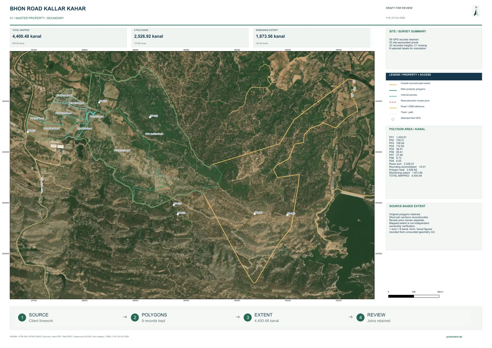
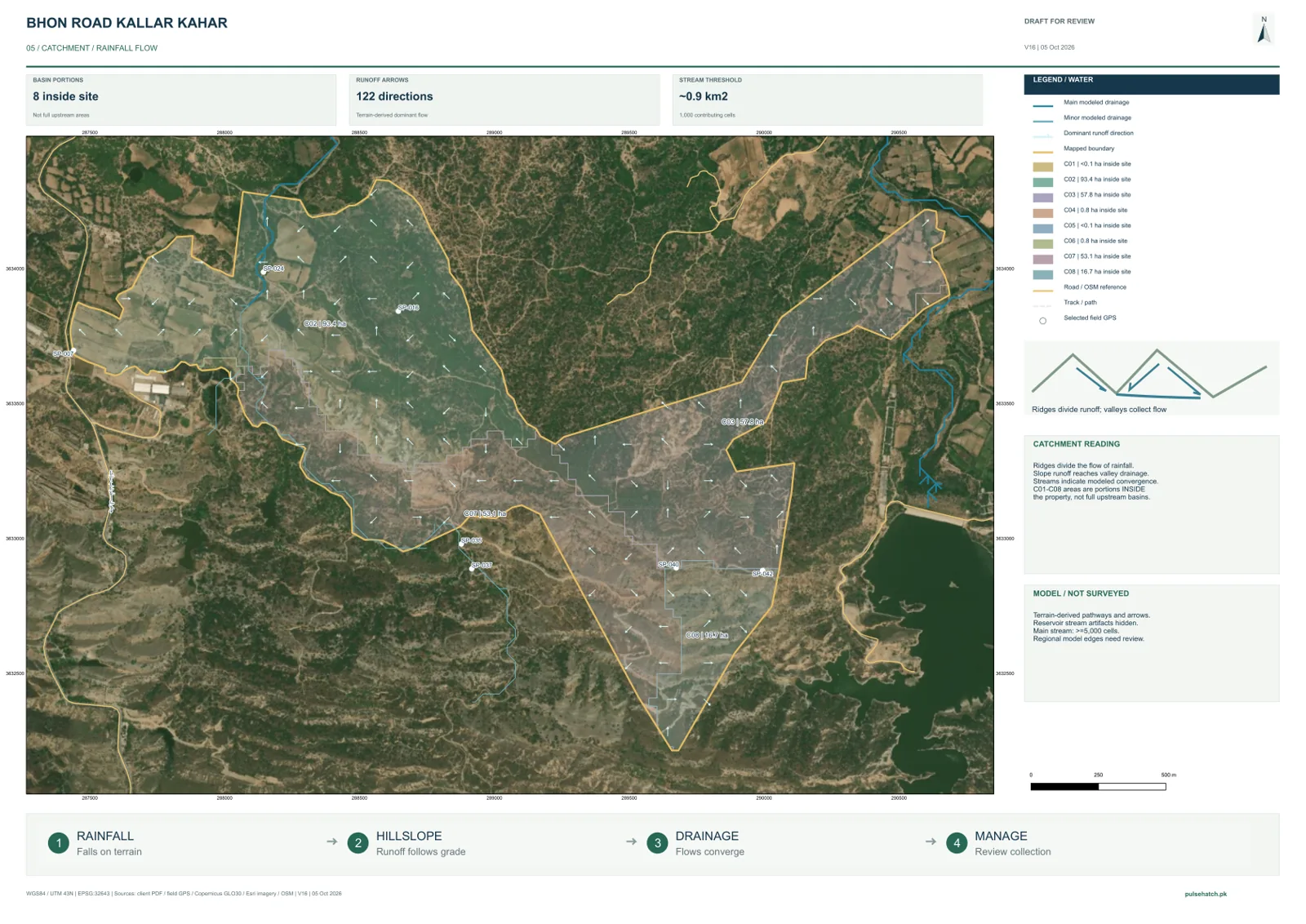
Bhon Road · Kallar Kahar · Punjab
From GPS Field Survey to a Six-Map Planning Atlas
A documented GIS workflow using field observations, client reference maps and terrain modelling. Includes contours, elevation, slope, catchment review and a preliminary site-water planning report.
59GPS records6GIS map sheets21V20 report pages
Field visit: 3 October 2026 · Report issued: 13 October 2026. Mapped extents and water-routing concepts are preliminary, not legal boundaries or final hydraulic designs.
Explore Case Study & Maps →
Field Survey & Water Planning · 2026
Ten-Acre Regenerative Agriculture Case Study
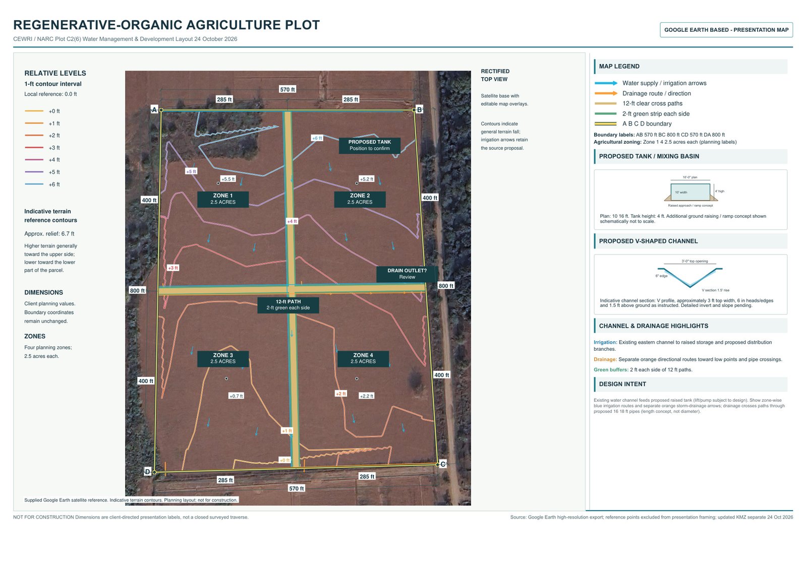
Rev12 · Terrain & water planning
One coordinated plan for terrain, access and water
Rohail Khalid combined field references, four numbered zones, dimension chains, 1-ft relative terrain contours, 12 ft paths and proposed irrigation and drainage routes in the updated Rev12 map.
Explore the updated map, relative elevation differences, PDF downloads and layered Google Earth KMZ. Terrain contours are indicative; surveyed levels and hydraulics remain for verification.
Explore Case Study & Map →Social Channels
Real channels linked to Rohail Khalid and Pulse Hatch.Connect With Me

Professional Websites for Experts & Businesses
Profiles · Portfolios · Project Showcases · Tools · Digital Support · Business Presence
 Rohail Khalid
Engineering · Mapping · Innovation
Meet Rohail Khalid
Technical fieldwork, civil engineering, GIS mapping and practical digital solutions through Pulse Hatch. Explore documented projects, professional services and my personal brand collection.

Rohail Khalid | Personal Brand
Professional Identity & Portfolio
Engineering, mapping and digital innovation — a personal collection of portraits, professional cards and brand artwork, with direct links to projects and ways to connect.
Professional Portrait
Civil Engineering · Surveying · GIS & Mapping · Digital Innovation.
Expert Introduction
Practical fieldwork, technical knowledge and selected projects. Discover the maps, reports and planning work behind this profile.
Professional Cards
A personal introduction in the green and gold Pulse Hatch style. Keep learning. Keep growing.

Engineering, Mapping & Innovation
People, places and technology brought together through civil engineering, GIS mapping and practical digital solutions.

Keep Learning · Keep Growing
Civil engineering, GIS & mapping, AI & digital innovation, and continuous professional growth.

Personal Brand · English & Urdu
Explore both language editions of my professional identity collection.
Styled brand artwork is a creative illustration. Original field photographs, survey references and project reports are available in the documented case studies.
Reviews
Client Feedback
Verified Review DeskGenuine client, student and collaborator feedback only.
☆☆☆☆☆
Reviews are published only after verification.Log in to leave a verified review →
✓ VERIFIED ONLY
No fabricated testimonial is shown.The first approved review will appear here with the reviewer's real display name and rating.Q / A
Quick Questions
Open a question to see the answer.How do I request surveying, GIS or mapping work?
Choose the relevant service above or use the WhatsApp project button. Share the project area, required output and deadline; sensitive site information can stay private until scope is confirmed.
Can I request a website, portfolio or digital project through this profile?
Yes. Website, professional portfolio and digital project enquiries are routed through Pulse Hatch so the correct service and project workflow can be selected.
Are engineering calculator tools available here?
Calculator and engineering tools are being released through Pulse Hatch in phases. Items marked Coming Soon are not presented as finished services.
How are reviews approved?
A reviewer must log in first. A submitted review stays pending until verification; only genuine approved feedback is displayed publicly.
Can private project maps or site files remain confidential?
Yes. Public portfolio graphics may use anonymized or AI-generated visuals when real maps, coordinates, facilities or client information should not be exposed.
Contact
Get in Touch
Phone: Pulse Hatch Official Desk
Email: rohail.khalid2506@gmail.com
Official Location: F1, Bahria Enclave, Street 20, Islamabad, Pakistan
Website: pulsehatch.pk
Survey data, terrain analysis & GIS mapping
Referral reward: 10% of eligible received fees (PKR 7,000 on the full PKR 70,000 reference package). Reference project package: PKR 70,000, based on the Bhon Road quotation dated 5 October 2026. Final quotation depends on area, source data and agreed deliverables.
GIS Survey Data, Terrain & Mapping
PKR 70,000GPS data processing, boundary/base maps, terrain/contour/slope and drainage analysis, professional layouts and agreed revisions. Reference scope: Bhon Road quotation, 5 October 2026.
View service →Prices are for the stated scope. Domain, hosting, licences and outside provider fees are confirmed separately. See all published rates →
| GPS / field data processing | PKR 10,000 |
|---|---|
| Boundary & satellite base mapping | PKR 10,000 |
| Terrain, contour & slope maps | PKR 15,000 |
| Drainage & watershed maps | PKR 15,000 |
| Map layouts & cartographic design | PKR 12,000 |
| Revisions & digital deliverables | PKR 8,000 |
| Total project package | PKR 70,000 |
50% advance; 50% on completion of agreed deliverables. Additional field visits, Total Station/DGPS surveys and detailed engineering design are quoted separately. Accuracy depends on available field/GPS and terrain data. View the mapping case study → · Request a scoped quote →